


GPS Field Area Measure
GLand
Description of GPS Field Area Measure: GLand
GLandMeasure is the ultimate land measurement app using GPS. Easily measure land area, calculate acreage, measure distances, define property boundaries, and survey fields with accuracy. Perfect for farmers, landowners, surveyors, and real estate professionals. Use this GPS area calculator to map your farm, measure property lines, analyze terrain, convert units, and export data in KML, GeoJSON, or CSV. Supports UTM, MGRS, DMS, and more. Whether you're managing fields or measuring plots, GLandMeasure is the all-in-one mapping and land survey tool you can trust.
Tired of inaccurate land estimates? GLandMeasure is your ultimate precision tool for all land surveying and GIS needs. Easily and quickly calculate areas, measure distances, determine perimeters, define property lines, and manage complex geospatial data with confidence.
Discover the Power of GLandMeasure:
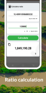
🌟 Accurate Area Calculator: Instantly find the area of any land, field, farm, lot, or property. Perfect for calculating acreage!
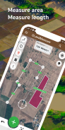
🛰️ GPS Land Measurement: Utilize high-precision GPS for reliable field area data, mapping, and boundary surveys.
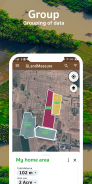
🚶 Measure Area by Walking: Simply walk the perimeter to map out exact boundaries – ideal for irregular shapes, paths, and paddock measurements!
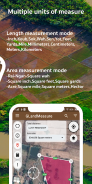
📏 Easy Distance Tool: Quickly and conveniently calculate distances between points on your map or on-site.
🌐 Flexible Unit Converter: Effortlessly switch between various units: Acres, Square Feet (sq ft), Square Meters (sq m), Hectares (ha), Square Kilometers (sq km), Miles (mi), Kilometers (km), Feet (ft), Yards (yd), and more.
GLandMeasure is the Go-To App For:
Farmers & Agricultural Professionals: Manage farmland, measure field acreage, plan crops, and optimize resources.
Real Estate Agents, Appraisers & Developers: Confidently measure property sizes, verify lot dimensions, and enhance listings.
Land Surveyors, Engineers & GIS Professionals: Obtain reliable data for surveys, construction, environmental assessments, and GIS analysis.
Homeowners & Landowners: Accurately determine your property lines, plan landscaping or fencing projects.
Outdoor Enthusiasts & Planners: Measure trails, map out recreational areas, or plan construction layouts.
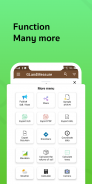
Advanced GIS & Surveying Capabilities:
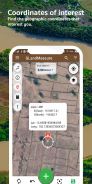
🌐 Multi-Coordinate System Support: Work seamlessly with various global and local coordinate systems including GEO (Latitude/Longitude), DMS (Degrees, Minutes, Seconds), UTM (Universal Transverse Mercator), MGRS (Military Grid Reference System), Geohash, and Plus Codes.
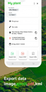
📤 Versatile Export & Sharing Options:
Share coordinates instantly.
Export your project data to KML, GeoJSON, Excel (CSV), and professional PDF reports.
⛰️ Elevation & Terrain Analysis:
Access altitude data for any point or area.
Visualize terrain with contour lines for better understanding of topography.
Calculate soil volume (cut and fill estimations) for earthworks and landscaping projects.
🌳 Area Analytics: Perform quick tree count estimations within measured areas for forestry or planning.
🌦️ Local Weather Forecast: Get on-the-spot weather predictions integrated for your surveyed location.
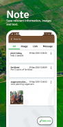
📍 Save & Manage Points of Interest: Easily save, label, and manage important locations, waypoints, or survey markers.
📸 GIS Camera: Capture georeferenced photos to document fieldwork, tag specific points of interest, and integrate visual data with your maps. (This assumes capturing photos with location data, not area measurement via camera view).
⏱️ Built-in GPS Speedometer: Ensures accurate tracking and data collection during walk measurements.
🗺️ Clear Satellite Map View: Provides excellent visual context for your measurements and planning.
Stop guessing. Start measuring with confidence! Download GLandMeasure today for the most comprehensive, user-friendly, and accurate solution for all your land, field, distance measurement, and GIS data needs!
GPS Field Area Measure : GLand - Version 3.23.2
(30-06-2025)GPS Field Area Measure: GLand - APK Information
APK Version: 3.23.2Package: com.gis.toptoshirou.landmeasure.GlandmeasureLatest Version of GPS Field Area Measure : GLand
Other versions


Apps in the same category


